The RS10 brings together GNSS RTK, laser scanning and visual SLAM technologies into a single, streamlined platform. This integration boosts both efficiency and accuracy across indoor and outdoor 3D scanning and surveying tasks. It allows surveyors to keep working in areas with poor GNSS coverage, offering outstanding flexibility in the field.
Ideal for applications such as surveying, BIM, forestry, powerline inspection and underground mapping, the RS10 is a highly versatile solution for Australian professionals looking to expand their capabilities. BOOK A DEMO REQUEST A QUOTE

Features

GNSS RTK + SLAM
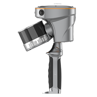
Design
Combine RTK, laser, and visual SLAM to achieve 5cm absolute accuracy.

Real-Time Mapping
Real-time georeferenced point clouds in the field.

High-Precision
Accuracy
1 cm relative accuracy with GNSS and LiDAR technologies.

Hot-Swap Batteries
60 minutes per battery with hot-swap capability for uninterrupted operation.
Benefits
Industry Use Cases

As-Built
Surveying

Forestry and Vegetation
Mapping

Utility
Inspection

Augmented Topographic
Surveying
Product Specifications

Laser Scanner
- Channels : 16 or 32
- Range : 120 or 300 m
- Scanning rate : 320.000 or 640.000 pulses/sec
- Field of view : 210° x 170°
- Returns : Up to 2
Sensors
- Camera : 15 MP (3x 5 MP)
Positioning
- GNSS : Full GNSS
- Absolute accuracy : < 5cmH / < 5cmV
- Relative accuracy : < 1 cm
