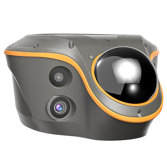
The ViLi i100 is CHCNAV’s flagship GNSS RTK receiver, combining advanced satellite signal filtering, enhanced SFix 2.0 positioning, and innovative Vi-LiDAR technology. It delivers reliable centimetre-level accuracy even in challenging GNSS conditions, giving professionals the confidence to push beyond the limits of traditional GNSS surveying in Australian environments. BOOK A DEMO REQUEST A QUOTE
Features

Confident and Consistent Accuracy
5cm accuracy, even in challenging GNSS environments. Once right, always right.

Enhanced SFix 2.0 Engine
5cm accuracy within 20m in GNSS-denied Areas.

3D Point Cloud Earthwork Calculation
Simply scan, define the boundary, and get instant results with 99.98% accuracy.

Vi-LiDAR Contactless Survey
Capture a photo once and extract survey points in batches.
Benefits
Powered by next-gen sensor fusion and 3D laser scanning, the ViLi i100 redefines accuracy and reliability. It filters GNSS satellite signals affected by blockage or reflection, ensuring stable, jump-free 5 cm accuracy in challenging environments such as alleys, forests, or near high-rise buildings. Once right, always right.
With its SFix 2.0 engine, ViLi i100 delivers 5 cm accuracy within 20 meters in GNSS-denied areas by using 860,000 pts/sec LiDAR and SLAM-based constraints. Trained on tens of thousands of real-world datasets, it resolves GNSS outages without the need to switch to a total station.
With high-precision laser sensing and LandStar software, ViLi i100 enables real-time cut and fill volume calculations on site with 99.98% accuracy. Simply scan, set boundaries, and receive instant results. No surface contact is required, making the workflow accurate, efficient and safe.
With Vi-LiDAR, capture a scene once and batch-select target points to extract multiple 3D coordinates without the need to aim precisely or stay steady. The ViLi i100 eliminates the impact of hand tremors, increases speed and safety, and delivers 5 cm accuracy even at 15 meters with its 8 MP telephoto camera.
ViLi i100 is an all-in-one GNSS receiver combining standard RTK features with next-gen innovation. Paired with LandStar software, it supports CORS, UHF, and PPP modes. Dual cameras enable CAD and AR visual stakeout, increasing efficiency by 50%. The ViLi i100 is reliable and built for professionals.
Industry Use Cases

GNSS-obstructed Environments

GNSS-denied Environments

Earthwork Volume Calculation

Contactless Surveying
Product Specifications

Connectivity
- Wireless : Bluetooth, Wi-Fi
- Cellular : No
- Modem : 410 - 470 MHz, Rx only
- Ports : 1 x USB V3.0 Type-C port, 1 x UHF antenna port
LiDAR
- Range : 30 m @ 10% reflectivity 70 m @ 80% reflectivity
- FOV : H: 360° V: 90°
- Eye - Safety Class : Class 1 (EC60825 - 1:2014) eye - safe
- Point Frequency : 860,544 pts/s (single - echo mode)
- Accuracy (Typical) : 1.5 cm (1 σ)
Positioning
- GNSS : Full GNSS
- IMU : 200 Hz
- Precision max. : 0.8cmH / 1.5cmV
Physical
- Weight : 1.39 kg
- Screen size : 208 x 162 x 95.5 mm
